Route calculation
The MapTrip Server API provides route calculation functionality through the endpoint [GET] /route.
A route is defined by information such as distance, driving time, and estimated time of arrival,
detailed driving instructions and the geometry of the route's path.
Users can customize routes based on specific requirements by adjusting various parameters. These parameters may include vehicle type, dimensions, or preferences such as avoiding toll sections. Additionally, users can request multiple alternative routes simultaneously if needed.
Our system interacts with Detour to consider factors like blocked or unblocked road sections and turning restrictions.
It's important to note that all requests to this endpoint must include a valid Token for authentication. To test the endpoints in this tutorial, see the MapTrip Server API test page.
Calculate a route
Requesting to [GET] /route
To initiate a route calculation request, the following minimum parameters are required:
provider: A string indicating the map data provider. Possible values areTomTom,HERE, andOSM.from: The coordinates of the starting point in WGS84 decimal degrees.to: The coordinates of the destination point in WGS84 decimal degrees.
See Coordinate Format for Start and Destination for details on from and to.
Example
This curl command fetches a route from Bonn to Cologne:
curl -X GET "https://api.maptrip.de/v1/route?provider=TomTom&from=50.73656%2C7.09206&to=50.93512%2C6.955051" -H "accept: application/json" -H "Authorization: Bearer <token>"
Please note that the response provided below is for example purposed only and is shortened for brevity.
1 2 3 4 5 6 7 8 9 10 11 12 13 14 15 16 17 18 19 20 21 22 23 24 25 26 27 28 29 30 31 32 33 34 35 36 37 38 39 40 41 42 43 44 45 46 47 48 49 50 51 52 53 54 55 56 57 58 59 60 61 62 63 64 65 66 67 68 69 70 71 72 73 74 75 76 77 78 79 80 81 82 83 84 85 86 87 88 89 90 91 92 93 94 95 96 97 98 99 100 101 102 103 104 105 106 107 | |
Date Format and Time Zone
Please note that the estimated time of arrival is represented as an ISO 8601 string in UTC (indicated by the trailing 'Z') and must be converted to your local time zone.
Coordinate Format for Start and Destination
The start and destination of a route are specified as coordinates in WGS84 decimal degrees
(EPSG:4326). They have to be provided in the format latitude,longitude,
for example 50.73656,7.09206.
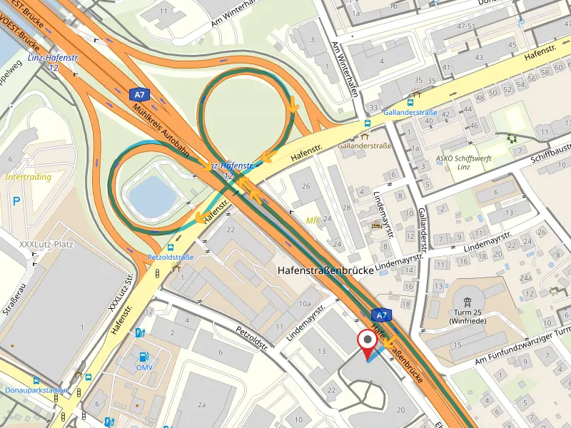
Optionally, you can add a street name. If the destination is located at the intersection of multiple streets (e.g., at a crossroads or between a highway and a street), this ensures that the route is calculated using the desired street.
These two images show a route to the same coordinates. In the first screenshot, no road was specified. The route ends with an off-road section from the highway to the destination. In the second image, the desired road was specified:
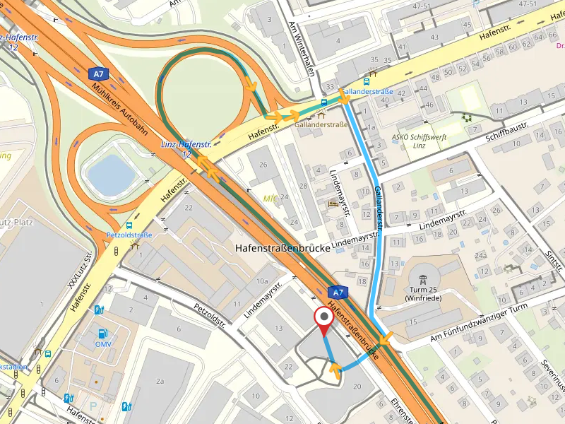
To add a street name, use the format latitude,longitude,street, e.g., 48.31532,14.30516,Am Fünfundzwanzigerturm.
Do not add the house number and make sure you use the same spelling as in the map data.
Here is an example with a street name for the destination:
curl -X GET "https://api.maptrip.de/v1/route?provider=TomTom&from=48.28083%2C14.30904&to=48.31532%2C14.30516%2CAm%20F%C3%BCnfundzwanziger%20Turm" -H "accept: application/json" -H "Accept-Language: de" -H "Authorization: Bearer <token>"
Output Format and Components of a Route
The output format of a route may consist of the following parts:
summary: This includes essential details such as distance, driving time, and estimated time of arrivaldirections: Detailed driving instructions are provided, guiding users through the route (e.g., "Turn right onto Great Russell Street" or "Take the second exit at the roundabout")geometry: The route's path is represented by a series of coordinates. It is output as a GeoJSON FeatureCollection that can be rendered in a map
You can use the parameter output to specify which of these parts are returned. To do this,
provide a comma-separated list, e.g. output=geometry to query the geometry only, or
output=summary,geometry for both the summary and the geometry.
If output is not specified, summary, directions, and geometry are returned by default.
International Routes
Routes can cross national borders. The countries attribute of the summary lists all countries with their ISO 3166-1 alpha-3 code through which the route passes. For each country, you receive the length, travel time and length of the roads with tolls. In addition, directions contains an entry at each border crossing.
This is the summary of a route from Aachen (Germany) to Hasselt (Belgium) via the Netherlands:
1 2 3 4 5 6 7 8 9 10 11 12 13 14 15 16 17 18 19 20 21 22 23 24 25 26 27 28 29 30 31 32 33 34 35 36 37 38 39 40 41 42 43 44 45 46 47 48 49 50 51 52 53 54 55 56 57 58 59 60 61 62 63 64 65 66 67 68 69 70 71 72 73 74 75 76 | |
Change the Language of the Driving Directions
The driving directions each have a textual description. These texts are in English by default. If you want to change the language, you have to add the HTTP header Accept-Language. Currently supported languages are English (en), German (de) and Ukrainian (uk).
To get the same route as in the previous section, but with German texts, use this command:
curl -X GET "https://api.maptrip.de/v1/route?provider=TomTom&from=50.73270%2C7.09630&to=50.94212%2C6.95781" -H "accept: application/json" -H "Accept-Language: de" -H "Authorization: Bearer <token>"
If the header contains several languages, the first supported language is used. All these values for Accept-Language return German texts:
dede-DEde-CH,en-USfr-CH, fr;q=0.9, de;q=0.8
1 2 3 4 5 6 7 8 9 10 11 12 13 14 15 16 17 18 19 20 21 22 23 24 25 26 27 28 29 30 31 | |
This will also return German texts for the attributes title and description of the obstacles along the route.
Route with waypoints
You can use waypoints for the route. We differentiate between intermediate destinations and via points:
- Intermediate destinations must be reached like the final destination.
- Via points are used to roughly define the course of the route. For instance, users can specify that the route should be calculated via a certain city or highway.
An intermediate destination is defined by a coordinate in WGS84 decimal degrees (EPSG:4326). It has the same format as the start and destination of the route, e,g, 50.83821,7.09176. A via point has an additional radius in meters: 50.83821,7.09176,1000 is a via point with a radius of 1 kilometer.
To use multiple waypoints for your route, use a semicolon separated list. This example shows an intermediate destination and a via point with a radius of 500 meters:
50.8382171,7.0917674,500;51.7782142,7.0412278,500
Here is an example of a route with two via points:
curl -X GET "https://api.maptrip.de/v1/route?provider=TomTom&from=50.73270%2C7.09630&to=50.94212%2C6.95781&waypoints=50.8382171%2C7.0917674%2C500%3B50.9222171%2C7.1017674%2C500" -H "accept: application/json" -H "Authorization: Bearer <token>"
All intermediate destinations will show up as destinations in the directions of the route. In addition to the other attributes,
they will have a length of the route from the start to this destination in meters, a drivingTime in seconds, an estimatedTimeOfArrival,
and the meters with toll up to this destination, like in this excerpt from the driving instructions of a route:
1 2 3 4 5 6 7 8 9 10 11 12 13 14 15 16 17 18 19 20 21 22 23 24 25 26 27 28 29 30 31 32 33 34 35 36 37 38 39 40 41 42 43 44 45 46 | |
Vehicle dependent route calculation
The route can be customized for a vehicle, its dimensions, weight and load. The following parameters help you to avoid roads, tunnels and bridges that you cannot or may not use with your vehicle:
vehicle: Specifies the vehicle type- car (default): A profile for normal cars
- truck_highway: A profile for trucks that prioritize highways over other roads. Routes tend to be faster, but have a longer distance with tolls
- truck_interurban: A profile for trucks that prioritize other roads over highways. Routes tend to be shorter and have less toll
width: The vehicle's width in metersheight: The vehicle's height in meterslength: The vehicle's length in metersweight: The vehicle's weight in kilogramsaxles: The number of axles of the vehicleaxleLoad: The vehicle's axle load in kilogramshazardousGoods:trueif the vehicle is transporting hazardous goods,falseotherwiseexplosiveMaterials:trueif the vehicle is transporting explosive materials,falseotherwisematerialsHarmfulToWater:trueif the vehicle is transporting materials harmful to water,falseotherwisetunnelRestrictionCode: When your vehicle is transporting hazardous goods and has a tunnel restriction code, you can provide it to avoid certain tunnelslowEmissionZonesandlezVignette: WhenlowEmissionZonesis set totrue, low emission zones are taken into account. In this case, you must also specify the vignette (None,Red,Yellow,Green) using the parameterlezVignette
Deprecated Vehicle Profile truck
Up to version 2.23, truck was used. In order to standardize the terms used in our applications and define them more clearly, we have been using truck_highway instead since version 2.24. If your application still uses truck, it is replaced by truck_highway internally.
This example calculates a route for a truck with a width of 2.45 meters, a height of 2.8 meters, a weight of 25 tons (i.e. 25000 kilograms), 5 axles, an axle load of 8 tons, and a load hazardous to water:
curl -X GET "https://api.maptrip.de/v1/route?provider=TomTom&from=50.73270%2C7.09630&to=50.94212%2C6.95781&vehicle=truck_highway&width=2.45&height=2.8weight=25000&axles=5&axleLoad=8000&materialsHarmfulToWater=true" -H "accept: application/json" -H "Authorization: Bearer <token>"
Route Flavors
Flavors are variants of routes that are optimized differently. You can either use them to obtain a route that suits your use case, or to calculate several routes with different flavors and give the user a choice.
You can use these flavors:
DYNAMIC: The default flavor finds the fastest route under the current traffic conditions. This is used when you do not specify a flavor.DIRECT: This flavor returns the route that would be chosen under optimal traffic conditions, but adds the delay caused by the current traffic situation.LESS_TOLL: This flavor prefers routes that involve fewer toll roads but may have longer driving times.
For the endpoint [GET] /route, you can specify multiple flavors as a comma-separated list. In this case, you will receive multiple routes in return:
curl -X GET "https://api.maptrip.de/v1/route?provider=TomTom&from=50.73270%2C7.09630&to=50.94212%2C6.95781&startTime=NOW&vehicle=truck&traffic=true&flavors=dynamic%2Cdirect" -H "accept: application/json" -H "Authorization: Bearer <token>"
1 2 3 4 5 6 7 8 9 10 11 12 13 14 15 16 17 18 19 20 21 22 23 24 25 26 | |
Deprecated Parameter alternatives
Up to version 2.23, the parameter alternatives was used to query multiple alternative routes. Starting with version 2.24, alternatives is deprecated and replaced by flavors. It can still be used, but when both parameters are defined,flavors will overwrite alternatives.
Off-road starts and destinations
If the start or destination coordinate is not on a road, the nearest road is used for the route calculation. The GeoJSON in the response shows this part of the route as a straight line. It is not used for calculating the distance, driving time and ETA.
For an accurate estimate of the arrival time, you should take this straight-line distance into account. To do this, use the two attributes distanceStart for the distance from the start coordinate to the road and distanceDestination from the road to the destination coordinate. These are properties of the route summary:
1 2 3 4 5 6 7 8 9 10 11 12 13 14 | |
Air Lines at Start and Destination
The behavior of the API was changed with version 2.21. Up to version 2.20, these air lines were used for length, drivingTime and estimatedTimeOfArrival (with a very low speed). Starting with version 2.21, they are no longer taken into account and returned in the new attributes straightLineStart and straightLineDestination.
Obstacles along the route
In certain scenarios, a valid route may not be found for your specified vehicle and destination. However, you will still receive a route suggestion along with notes indicating road segments where potential issues may arise. These issues can stem from various reasons:
- A road segment may not be suitable for your selected vehicle type (e.g., you requested a truck route, but a road segment is closed for trucks).
- Your selected vehicle attributes may not align with the road segment requirements (e.g., the height or axle load of your vehicle exceeds the allowed maximum).
- The destination might be situated in a pedestrian zone or a residential area.
In such cases, the route summary attribute hasObstacles will be set to true, and the attribute obstacles will contain a list of road segments where obstacles are present. Each obstacle includes a type, title, description, and coordinates of the affected road segment. It's important to note that a single road segment may have multiple obstacles.
We recommend checking for obstacles and determining whether they affect your route after each route calculation.
Examples
Here's an example of the route summary with obstacles. In this instance, only one road segment is affected, but it encounters three different obstacles: the destination is within a pedestrian zone, within a resident-only area, and the vehicle type (truck) is prohibited on this road segment.
1 2 3 4 5 6 7 8 9 10 11 12 13 14 15 16 17 18 19 20 21 22 23 24 25 26 27 28 29 30 31 32 33 34 35 36 37 38 39 40 41 42 43 44 45 46 47 48 49 50 51 52 53 54 55 56 57 58 59 60 61 62 63 | |
If the allowed maximum of a vehicle attribute such as height is exceeded (i.e. the type is VEHICLE_ATTRIBUTE_VIOLATED), the attribute and the limit are also returned:
1 2 3 4 5 6 7 8 9 10 11 12 13 14 15 16 17 18 19 20 21 22 23 24 25 26 27 28 29 30 31 32 | |
Language-dependent attributes
If you use the HTTP header Accept-Language to receive the route directions in a language other than English, the values of the attributes title and description will also be in this language (see Change the Language of the Driving Directions). Use type instead if you want to show an icon for the type of obstacle.
Cost of a Route
Starting with version 2.24.0, the endpoints [GET] /route and [GET] /route/reference support the parameters costPerKilometer and costPerHour. If these parameters are provided, the total route cost is calculated and included in the route summary. If they are omitted or set to zero, no cost information is returned.
The total cost can consist of up to three components:
- a distance-based cost calculated using
costPerKilometer(e.g. fuel and vehicle cost) - a time-based cost calculated using
costPerHour(e.g. driver expenses) - toll cost (if applicable, see Toll)
Here is an example of a route ETA from Hamburg to Berlin:
curl -X GET "https://api.maptrip.de/v1/route?provider=TomTom&from=53.54880%2C9.98358&to=52.51840%2C13.40716&vehicle=truck_highway&costPerKilometer=0.3&costPerHour=36" -H "accept: application/json" -H "Accept-Language: en" -H "Authorization: Bearer <token>"
1 2 3 4 5 6 7 8 9 10 11 12 13 14 15 16 17 18 | |
Toll
For truck routes, the route summary will contain the property toll which specifies the length of the toll route in meters.
For routes that run completely or partially through Germany, you can optionally also receive the toll costs for TollCollect in Euros. Please contact our sales team for further information.
These parameters have to be present for toll costs:
vehiclehas to be truck_highway or truck_interurbanemissionStandardhas to be presentco2EmissionClasshas to be presentweighthas to be presentaxleshas to be present
Here's an example of a route from Cologne to Frankfurt for a 12t, 2 axles truck with emission standard Euro 6 and CO2 emission class 1:
curl -X GET "https://api.maptrip.de/v1/route?provider=TomTom&from=50.940533%2C6.959905&to=50.110884%2C8.679492&vehicle=truck_highway&weight=12000&axles=4&emissionStandard=Euro6&co2EmissionClass=1" -H "accept: application/json" -H "Accept-Language: en" -H "Authorization: Bearer <token>"
1 2 3 4 5 6 7 8 9 10 11 12 13 14 15 16 17 18 19 20 21 22 23 24 25 26 27 28 29 30 31 32 33 34 35 36 | |
Traffic
Traffic Scenarios for Calculated Routes:
There are three traffic scenarios that can affect calculated routes: a time-independent route, a future route using statistical traffic information, and a route starting within the next 45 minutes utilizing real-time traffic data.
Time-independent route
- If no start time is included, the server will provide a time independent route.
Example curl command (note the absence of traffic or start time):
curl -X GET "https://api.maptrip.de/v1/route?provider=TomTom&from=50.73270%2C7.09630&to=50.94212%2C6.95781" -H "accept: application/json" -H "Authorization: Bearer <token>"
Statistical traffic information
- When a start time that is more than 45 minutes in the future is provided, the server employs statistical traffic information based on historical data.
Example curl command:
curl -X GET "https://api.maptrip.de/v1/route?provider=TomTom&from=50.73270%2C7.09630&to=50.94212%2C6.95781&traffic=true&startTime=2024-05-27T15:16:12Z" -H "accept: application/json" -H "Authorization: Bearer <token>"
Real-time traffic information
-
For routes starting
NOWor within the next 45 minutes, MapTrip's real-time traffic data is available. If you want to calculate a route with live traffic, use the parameterstraffic=trueand eitherstartTime=NOWorstartTime=with an ISO 8601 string within the next 45 minutes. If you do not includetraffic=true, the server will provide statistical traffic information. -
Please note that as traffic situations change constantly, traffic information for the original request is only valid for approximately 45 minutes. Therefore, your application should send new requests to the server at set intervals along the route for constant traffic updates. Otherwise, the route will transition from real-time traffic to statistical traffic information after the initial request time is up.
No Live Traffic for OpenStreetMaps
The server only obtains live traffic data from TomTom & HERE maps. OpenStreetMaps does not provide this information. If the provider is set to OSM, a status of 400 will be returned.
Example curl command:
curl -X GET "https://api.maptrip.de/v1/route?provider=TomTom&from=50.73270%2C7.09630&to=50.94212%2C6.95781&traffic=true&startTime=NOW" -H "accept: application/json" -H "Authorization: Bearer <token>"
Response
The format of the response corresponds to that of the first example. Note that if using real time traffic, the delay will be a number corresponding to the delay time in seconds.
Delay on the Route
When live traffic data is used, the discrepancy between the driving time considering live traffic and the standard driving time (derived from statistical traffic data) is returned in seconds within the "delay" field in the route summary.
For routes computed without live traffic data, the delay is indicated as 0.
Integrating Detour
A notable functionality of route calculation with the MapTrip Server API is the capability to incorporate closures, turn restrictions, and similar factors, which can be established using the Detour endpoints or the MapTrip Detour Editor.
For detailed information, see Detour and route calculation.
Emergency Routing
There are two parameters that control whether and how emergency routing is active: emergencyRouting turns on the feature, which enables certain roads for route calculation. With emergencyRoutingRadius, you can specify a radius in meters around the destination in which additional rules apply:
- Turn restrictions are ignored
- One-way streets can be used in both directions
- Pedestrian areas become accessible
- Parks are accessible
If you want to use the blocked roads, but do not use the additional rules, you can specify emergencyRouting=true and emergencyRoutingRadius=0.
By default, emergency routing is disabled.
Example curl command which activates emergency routing and uses a radius of 1 km around the destination:
curl -X GET "https://api.maptrip.de/v1/route?provider=TomTom&from=50.73270%2C7.09630&to=50.94212%2C6.95781&emergencyRouting=true&emergencyRoutingRadius=1000" -H "accept: application/json" -H "Authorization: Bearer <token>"
Backwards compatibility
Up to version 2.20, there was only the parameter emergencyRoutingRadius. A value greater than 0 turned on emergency routing. To allow emergency routing with a radius of 0, we introduced the new parameter emergencyRouting. For backwards compatibility with applications which do not use the new parameter, a positive value for emergencyRoutingRadius will implicitly turn on emergency routing.
Additional Parameters
These additional parameters influence the behavior of the routing:
type: By default, you'll get the fastest route from the start to destination. If you want to use the shortest route instead, specify the parametertype=shortestavoidToll: You can set this parameter totrueto avoid roads with tollavoidFerries: You can set this parameter totrueto avoid ferriesavoidHighways: You can set this parameter totrueto avoid highways. This must not be used for routes which are longer than 100 kilometersuseTurnRestrictions: By setting this parameter totrue, you can totally ignore turn restrictions from the map data provider. If, for example, it is not permitted to turn left at a junction, withuseTurnRestrictions=truethe route will take the turn anyway. If you are not absolutely sure, do not set this parameter to true!joinGeometry: By default, the geometry of all road segments is joined to a single polyline in the response to easily render it in a map. You can prevent this by specifyingjoinGeometry=false
Query ETA, Driving Time Distance and Toll only
There are use cases where you do not need a route, but only the travel time or distance to a destination:
- To monitor the travel time depending on the traffic situation over a longer period of time
- To select the vehicle with the fastest route from several vehicles
- To check how much the toll is for a particular route
In these case, you can use the endpoint [GET] /route/eta, which only returns a summary with the most important
information about a route. The response contains the driving time and estimated time of arrival (ETA), the
distance and the distance with toll, and toll cost for Germany. In addition to the total amount,
the toll distance is also broken down by country.
This endpoint is slightly faster than the endpoint [GET] /route. The call is similar to that for [GET] /route with these differences:
alternativesis not availableflavorscan be used, but you must not specify more than one flavorjoinGeometryis not available (as no geometry is returned)acceptLanguageis not available (as no textual driving directions are returned)
Example
This example queries the information for a route from Aachen (Germany) to Hasselt (Belgium) via the Netherlands:
curl -X GET "https://api.maptrip.de/v1/route/eta?provider=TomTom&from=50.775427%2C6.081487&to=50.929729%2C5.338221&vehicle=truck_highway&weight=40000&axles=5&emissionStandard=Euro1&co2EmissionClass=2" -H "accept: application/json" -H "Authorization: Bearer <token>"
Response
The result is a list of one summary object. As you can see from the highlighted lines, toll charges are only listed for Germany:
1 2 3 4 5 6 7 8 9 10 11 12 13 14 15 16 17 18 19 20 21 22 23 | |
If you query the ETA for a route with intermediate destinations by using waypoints without radius, the result will contain a summary
for each waypoint and the destination.
Reference Routes
A reference route comprises a series of coordinates that delineate the path of a route. Typically, it is stored as a CSV file with columns for latitude (lat) and longitude (lon). Supplying a reference route to MapTrip ensures precise navigation along a predefined route course. Refer to the endpoint [POST] /remote/route/reference/{device} and the
MapTrip Remote tutorial for more details.
The process of calculating a reference route closely resembles that of computing a regular route, with a few distinctions:
alternativesare not available for reference routesflavorscan be used, but you must not specify more than one flavor- the parameter
joinGeometryis not available for reference routes - you can specify a
distancein meters
When a distance is specified, the reference route comprises coordinates equidistant from each other at that specified distance. Otherwise, coordinates from the road data provider are used, which is recommended for employing reference routes in MapTrip.
Example
Here is an example of generating a reference route from Bonn to Cologne with coordinates every 2 km:
Example curl command:
curl -X GET "https://api.maptrip.de/v1/route/reference?provider=TomTom&from=50.73270%2C7.09630&to=50.94212%2C6.95781&distance=2000" -H "accept: text/csv" -H "Authorization: Bearer <token>"
This command requests a reference route using TomTom as the provider, starting from coordinates in Bonn and ending in Cologne, with coordinates generated every 2 km.
Response
lat;lon
50.7327;7.096295
50.742969;7.078457
50.751509;7.054411
50.763044;7.032813
50.778549;7.01863
50.794673;7.006095
50.809057;6.989683
50.821073;6.968552
50.838225;6.966467
50.856116;6.968817
50.874054;6.969652
50.891971;6.967971
50.903634;6.980888
50.919736;6.968516
50.936916;6.963111
50.942115;6.957802
Content-Type for Reference Routes
Please note that the header Content-Type for reference routes it text/csv, not application/json
like for most other endpoints.